A developed road system was one of the trademarks of the Roman Empire. Road infrastructure had a distinct military, economic and political purpose, and its role in the Romanisation of the conquered lands was crucial to the establishment of a strong Roman state. In addition to being well designed, Roman roads were durable and useful. In ideal conditions, they were planned to provide the shortest possible route between the starting point and the destination wherever possible and were characterized by long, straight sections. However, in most cases, the configuration of the terrain did not allow such tracing, which is why the roads were adapted to the complex characteristics of the terrain. Roman roads connected distant cities and provinces and were the “bloodstream” of the Empire.
Consequently, an important military-strategic road that connected Aquileia with Dyrrhachium and continued further east passed near the Roman colony of Epidaurum. Apart from the uncovered material remains, the basis for the study of Roman communication on our territory are various itineraries and maps, among which the Tabula Peutingeriana stands out. It is a medieval copy of a map representing a network of Roman roads drawn on 12 sheets of parchment. A schematic cartographic representation, 34 cm wide and slightly more than 6 meters long, is elongated in the east-west direction; it contains marked routes of main roads with marked travel stops and the distance between them. Cities marked with special signs are also shown, including Epitauro. The section of the main road from Narona to Scodra is shown on the Tabula Peutingeriana:
`Narona XII Ad Turres XIII Diluntum XIV Pardua XVI Ad Zizio VIII Leusinio‘ and so forth, towards Scodra.
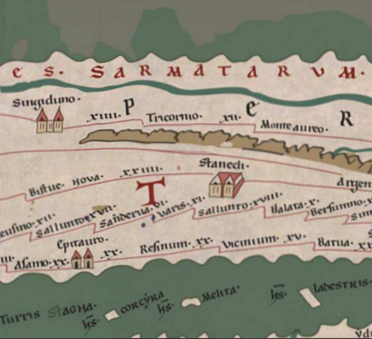
At the Ad Zizio travel stop a separate branch was formed, leading across Epidaurum to Scodra: `Ad Zizio XXVIII Assamo XX Epitauro XX Resinum XX Vicinum XV Batua XX Scobre.‘
The above is a series of travel stops and cities interconnected by the road with the indicated distance between them. Some of these locations have been uncovered, while the exact position of others remains unknown. For example, the archaeologist Dimitrije Sergejevski, who explored the route from Epidaurum to Anderba on several occasions in 1949, 1954 and 1960, believes Ad Zizio, where the route to Epidaurum separated from the main road, to be the contemporary Mosko, a village just north of Trebinje, while Bojanovski believes it to be Ukšići, a settlement located seven kilometres further north.
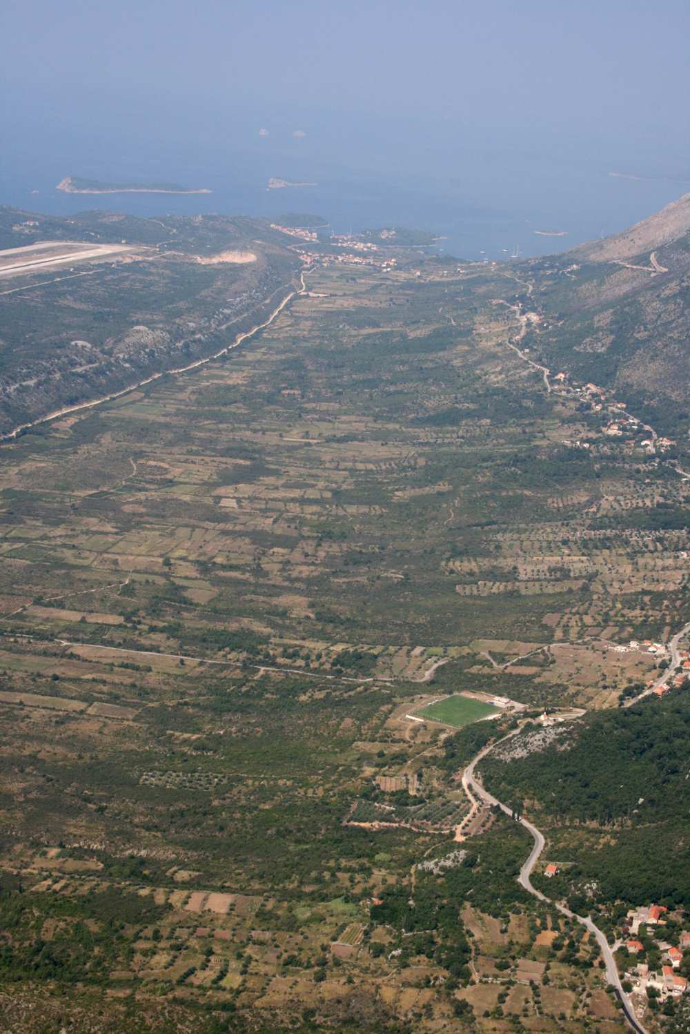
According to Bojanovski, the section of the road from Assamo (Trebinje) to Epidaurum led across Mokro polje to the village of Glavišće, descending down the hill to the castrum of Spilan, a fort located above Plat. The road then descended to Epidaurum via Gornji Obod and Donji Obod. Nine milestones were discovered on that road. The one in Lučki Dol, a rather illegible inscription mentioning Emperor Claudius, was discovered by Arthur Evans, who dates it back to 47-48 C.E.; it can be concluded that the road was built in those years. In Mokro polje, Evans found another milestone dating back to the 4th century, in the time of Valens and Valentinian I; the milestone in question most probably marked a repair of the road.
Another important road led from Epidaurum to Scodra along the coast of Konavle and the Montenegrin coast. Interestingly, there was an error of a cartographer or copyist on the map concerning the road leading from Epidaurum through Resinum (Risan) – Vicinium (Ulcinj) was listed as being located before Butua (Budva) on the way to Scodra (Skhodra).
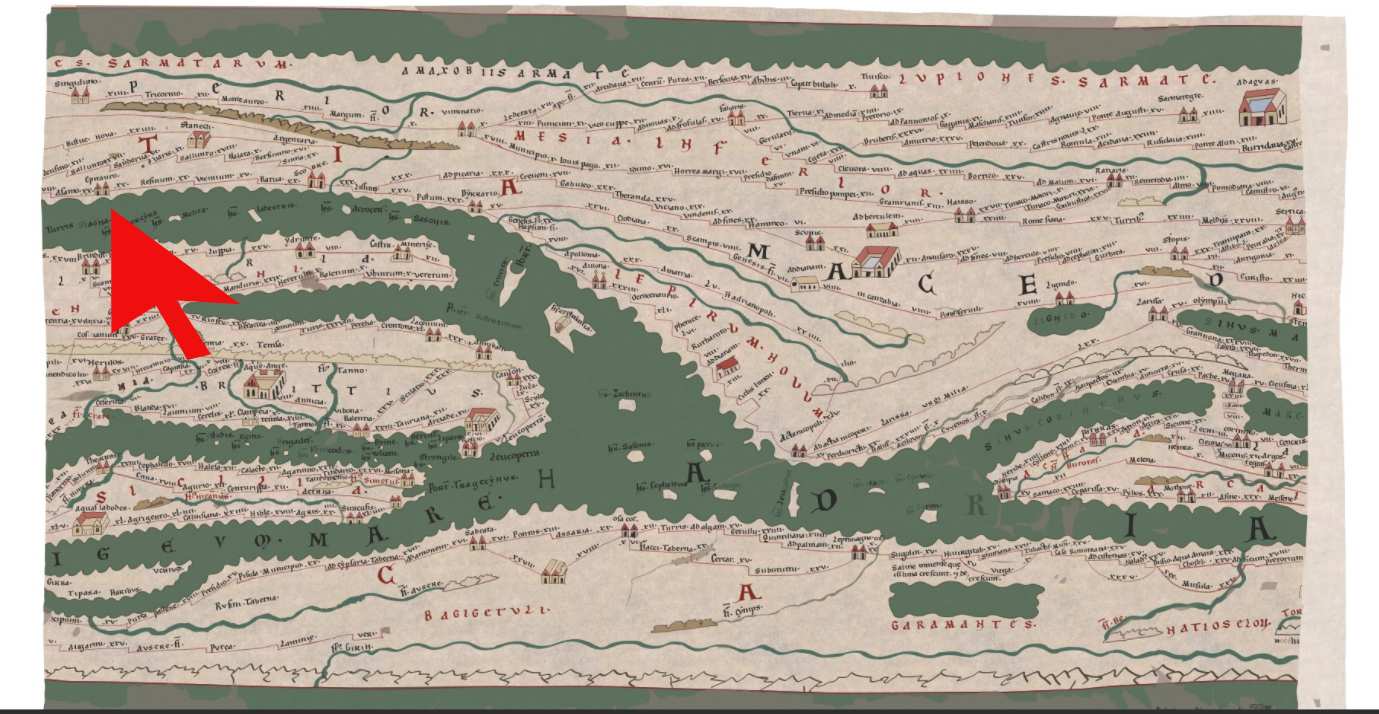
Map segment with Epidaurum marked
An entire network of local roads connected Konavle and had to fit into the ager limitation network. One road from Epidaurum led to Zvekovica, where it forked into a road leading to Gornja Banda and interconnecting the farms between Uskoplje and Ljuta, where it connected with a crossroad leading inland. The second road led from Zvekovica to Sutorina across the Konavle Valley. Two cohorts of Roman soldiers (Cohors VI voluntariorum and Cohors VIII voluntariorum) were stationed in the Epidaurum area during the 1st century and were probably involved in major public works such as road construction. An inscription found in Cavtat mentioning the name of the governor of the province of Dalmatia Publius Cornelius Dolabella, the Roman military unit Cohors VI Voluntariorum, its commander L. Purticius Atinas and two city magistrates presupposes the realization of a major public project. The project, whose name must have followed in the missing part of the text, was financed by the imperial treasury. It was probably the construction of a water supply system, but obviously such infrastructure required an accompanying road network, so it can be assumed that the said cohorts were included in their construction.
The road leading deep into the hinterland, which was also a part of the Epidauritan ager, in addition to military and strategic importance, had great cultural significance because it allowed for the influence of Roman culture to spread to the Trebišnjica Valley, as well as for a fast and efficient Romanisation of the aforementioned area.